2016 Census Neighbourhood Profiles are now online.
City of Winnipeg Neighbourhood Profiles
Census Profiles are available thanks to Statistics Canada and the Community Data Network, of which the City of Winnipeg is a member. The 2001 Census represents the most current socioeconomic information available.
Questions or clarifications can be emailed to: NeighbourhoodProfiles
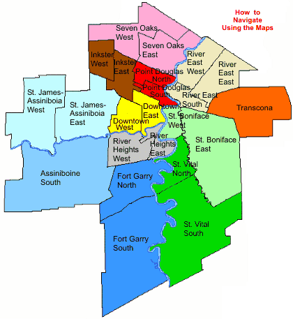
Click on the map to get information on the community and neighbourhoods in the area.

Profiles are also available for:
- The City of Winnipeg, Winnipeg Downtown Zoning By-Law, Inner City, Non-Inner City and Winnipeg Census Metropolitan Area (CMA)
- City Council Wards
- Community Areas (such as Fort Garry, River East, etc.)
Cross-neighbourhood comparisons and thematic maps are available for selected census topics.
For an alphabetical listing of all city neighbourhoods, click here.
The City of Winnipeg has compiled a list of the most commonly asked for census definitions.
Find out about the various geographies used and how they were determined.
Learn more about the role of the Community Data Network.
View maps depicting the City of Winnipeg neighbourhoods, community areas and council wards.
- Statistics Canada Census Homepage
- Statistics Canada 2011 Census Dictionary
- Statistics Canada 2006 Census Homepage
- Statistics Canada 2006 Census Dictionary
- Statistics Canada 2001 Census Homepage
- Statistics Canada 2001 Census Dictionary
- Statistics Canada 1996 Census Homepage
- Statistics Canada 1996 Census Dictionary
- Censuses available at Library and Archives Canada
- Statistics Canada National Household Survey (NHS) Homepage
- Statistics Canada 2011 National Household Survey Dictionary
- Economic Development Winnipeg
- Manitoba Bureau of Statistics (MBS)
