Site Accessibility Information Access Key 1 to Skip to Top Navigation Access Key 2 to Skip to the Three One One link Access Key 3 to Skip to City of Winnipeg Main Menu Access Key 4 to Skip to Left Navigation Menu Access Key 5 to Skip to Content area Access Key 6 to Skip to Right Sidebar content area Access Key 7 to Skip to Footer Links
Citizens Information Service
Public Works
Walk Bike Projects

West Alexander Pedestrian and Cycling Corridor

Connecting McPhillips Street to Sherbrook Street

This project is now complete.

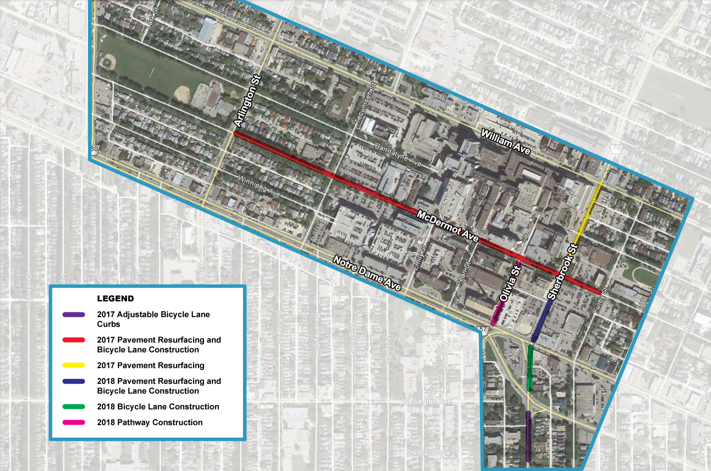
In 2018 the remaining paving of the roadway, and construction of the bi-directional bicycle lane along McDermot Avenue from Arlington Street to Furby Street will be completed. In addition to a dedicated bike lane, the project includes enhanced street crossings for pedestrians at select intersections and street resurfacing. McDermot Avenue will also permanently switch to one-way eastbound from Arlington Street to Sherbrook Street. View the design.


Project Updates

April 2018

In 2018 the remaining paving of the roadway, and construction of the bi-directional bicycle lane along McDermot Avenue from Arlington Street to Furby Street will be completed. In addition to a dedicated bike lane, the project includes enhanced street crossings for pedestrians at select intersections and street resurfacing. McDermot Avenue will also permanently switch to one-way eastbound from Arlington Street to Sherbrook Street. View the design.

December 2017

Work has ceased for the 2017 construction season and will resume in Spring of 2018 to complete the paving of the roadway and construction of the bike lane on McDermot Avenue.

August 2017

Construction of the West Alexander Pedestrian and Cycling Corridor and associated street work commenced on Monday, August 28. McDermot Avenue has been switched to one-way eastbound from Arlington Street to Sherbrook Street for construction and will remain a one-way street after construction. Please see the routing map for suggestions on how to get to area destinations.

Access to area businesses and the Health Sciences Centre will be maintained as much as possible throughout construction. Short term private approach closures may be required to facilitate construction and will be reviewed with residents/businesses prior to the construction taking place. Parking will be restricted on McDermot Avenue during construction. For more information please see the August construction notice.

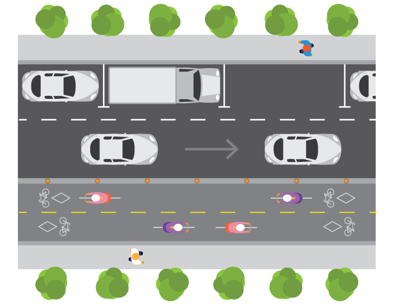
Bi-directional Bike Lane

June 2017

Starting in August 2017 work will begin to resurface McDermot Avenue from Arlington Street to Furby Street, adding a two-way protected bike lane. As part of this work McDermot Avenue will permanently switch to one-way eastbound along this segment. For more information, please see the June construction notice.

Construction notices related to work in the project area will be posted here prior to construction. If you have questions about road renewals or want to receive construction notices via email please contact Rebecca Hewett at Stantec Consulting Ltd. 204-478-8954.

Maps

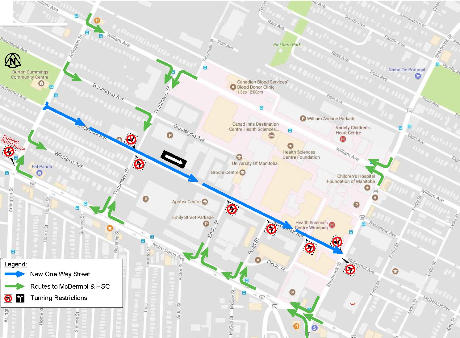
Routing Map
routing map

The above turning restrictions will be implemented throughout construction and will remain in place following project completion


How do I access the Health Sciences Centre now that McDermot Avenue is a one-way street?

Vehicles travelling southbound on Sherbrook Street will no longer be able to turn right onto McDermot Avenue. To access HSC:

  • Turn right onto Notre Dame Avenue
  • Turn right onto Pearl Street, Emily Street or Tecumseh Street.
  • Turn right onto McDermot Avenue
  • You may also turn right onto William Avenue before Sherbrook Street and access McDermot Avenue via Tecumseh Street.

Vehicles travelling northbound on Sherbrook Street will no longer be able to turn left onto McDermot Avenue. To access HSC:

  • Turn left at Notre Dame Avenue
  • Turn right onto Pearl Street, Emily Street or Tecumseh Street.
  • Turn right onto McDermot Avenue

Or

  • Turn left onto William Avenue
  • Turn left onto Tecumseh Street
  • Turn left on McDermot Avenue

Area Map

Map

Background

In November 2011, City of Winnipeg Council approved the Transportation Master Plan (TMP). A key goal of the TMP is to expand the range of travel options that are available to residents, workers, and visitors, as well as to ensure that people are not dependent on one single mode of transportation. The TMP also calls for the development of the Pedestrian and Cycling Strategies.

In 2015, City Council approved the Winnipeg Pedestrian and Cycling Strategies, which provide a long-range policy framework for active modes of transportation for the next 20 years.

The 2015 Pedestrian and Cycling Action plan was adopted by Council in May 2015, where this study was approved. Feedback received during this process was incorporated into preferred design option, which includes a two-way protected bike lane McDermot Avenue between Arlington Street and Furby Street.

Frequently Asked Questions

Open all | Close all

Will I be able to access area businesses/the hospital during construction?
Access to area businesses and the Health Sciences Centre will be maintained as much as possible throughout the project. Short term private approach closures may be required to facilitate construction and will be reviewed with residents/businesses prior to the construction taking place. Parking will be restricted on McDermot Avenue during construction.
Why a pedestrian and cycling corridor through West Alexander?
The City is committed to creating a pedestrian and cycling network that is safe and accessible for people of all ages and abilities. The City’s Pedestrian and Cycling Strategies identify the West Alexander neighbourhood as a high priority. This new protected bike lane is an important connection between current and future cycling infrastructure and a high number of pedestrians and cyclists regularly access the area.
What traffic changes are happening as part of this project?

In addition to McDermot Avenue becoming a one-way street eastbound between Arlington Street and Sherbrook Street, the following changes will be in place during construction and after construction is complete:

  • Vehicles travelling southbound on Arlington Street will no longer be able to turn left onto McDermot Avenue (this turning restriction will be implemented part way through project construction).
  • Vehicles travelling eastbound on McDermot Avenue from McPhillips Street will be required to turn left or right at Arlington Street (this access restriction will be implemented part way through project construction).
  • Vehicles travelling southbound on Sherbrook Street will no longer be able to turn right onto McDermot Avenue.
  • Vehicles travelling northbound on Sherbrook Street will no longer be able to turn left onto McDermot Avenue.

Please see the suggested routing map for suggestions on how to get to area destinations.

Why was a two-way protected bike lane on the right side of McDermot Avenue chosen?
  • This design best accommodates the inclusion of all modes of transportation (pedestrians, a wide range of cyclists, transit users and motorists).
  • Separated bike lane is safer for cyclists and is the most desired facility type.
  • The south side has fewer private approaches.
  • The Emily Street and McDermot Avenue intersection will be raised to improve pedestrian crossings and visibility.
  • The wider bike lane has enough room for cyclists to pass each other.
  • The wider bike lane provides ease of maintenance (clearing of debris, leaves, snow and sand).
  • The majority of feedback received supported this option.
  • The majority of stakeholder feedback indicated the importance of maintaining parking, loading and access to approaches on the north side of McDermot Avenue.
What criteria does the City use to decide what gets built?
The City goes through a formal steering committee evaluation process upon completion of the study and public engagement. The evaluation criteria weighs the different road user requirements and factors in feedback from public and stakeholders in the criteria. The weighted evaluation criteria includes: Safety (20%); Pedestrian and Cycling Environment (35%); Vehicular Operations (35%); and Construction and Maintenance (10%).
How will this project maintain and enhance safety?
Separating cyclists, pedestrians and vehicles is the safest way to accommodate each mode of transportation. In addition to a dedicated bike lane, the project includes enhanced street crossings for pedestrians at select intersections. The City is committed to creating a pedestrian and cycling network that is safe and accessible for people of all ages and abilities.
How much will this project cost?
The McDermot Avenue – Arlington Street to Furby Street project is estimated to cost $1.3 million.
Will there be a loss of on-street parking and loading zone space?
Local businesses and other area stakeholders were directly consulted to ensure that improved cycling infrastructure balances the needs of area businesses, service providers, visitors and residents. The final design maintains as much on-street parking and loading as possible.
Will vehicular access to private property be limited by new pedestrian and cycling infrastructure?
Vehicular access would not be closed as a result of this project unless requested by the landowner. Where vehicles are required to cross a protected cycling lane for access, signage and surface treatments will promote awareness for both cyclists and vehicles.
Winter lasts about half of the year, so why are we building bike lanes?
The City’s Pedestrian and Cycling Strategies commits to providing and maintaining safe walking and cycling facilities year-round.
Will new cycling lanes connect with existing cycling routes?
Upgraded cycling routes through West Alexander will ensure an enhanced connection across Sherbrook Street to existing painted lanes on McDermot Avenue and Bannatyne Avenue, with options currently being studied to upgrade to protected lanes. Also, this project will connect to future cycling facilities on Arlington Street, Maryland Street, Sherbrook Street and the future Ruby/Banning neighbourhood greenway.
How were people consulted about this project?
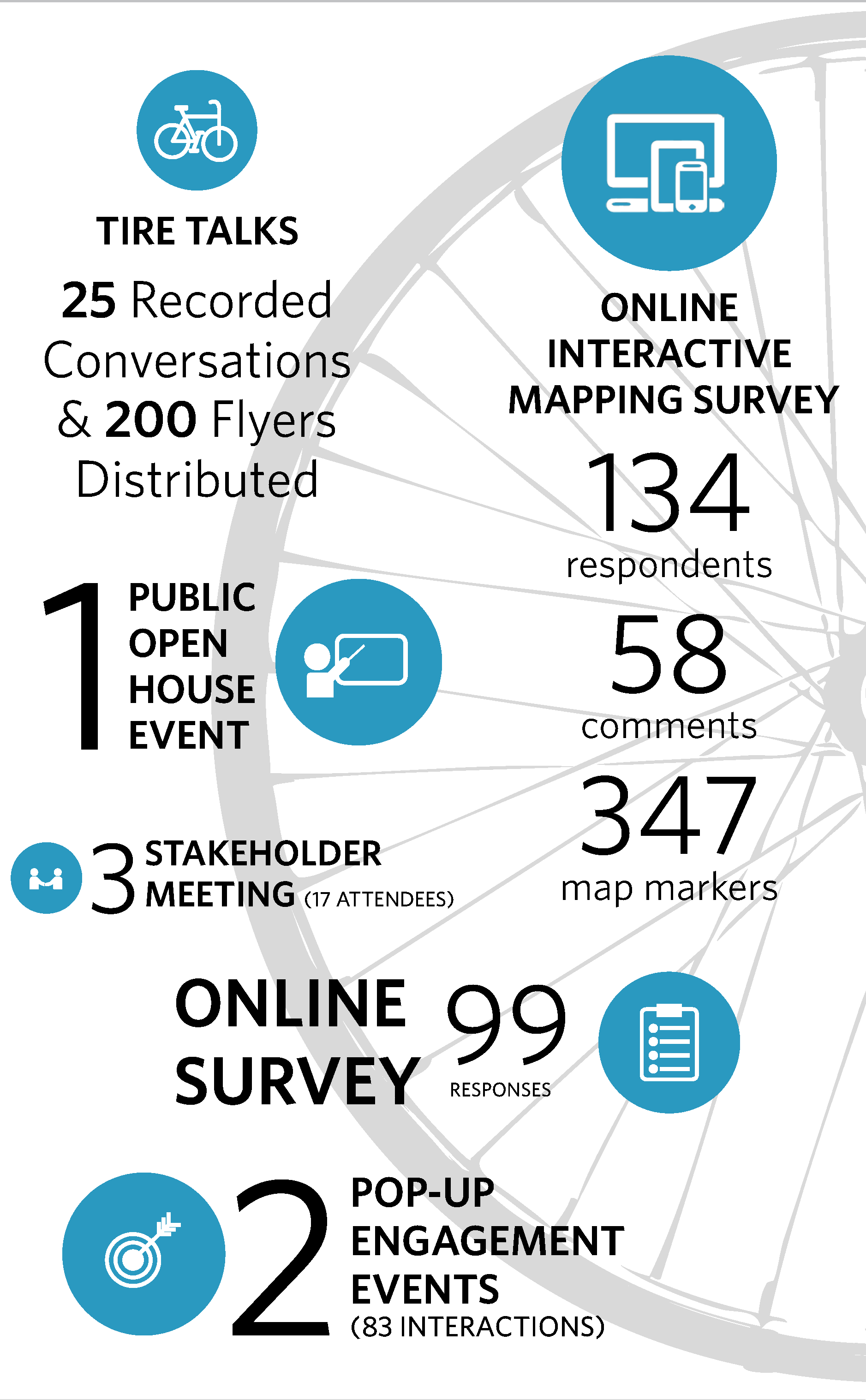
Public input is a key component of these projects. In September 2015, the City of Winnipeg initiated a public engagement process to receive input on the West Alexander Pedestrian and Cycling Corridor. Engagement opportunities included an online interactive mapping survey, two pop-up engagement events, tire talks, three stakeholder meetings, online feedback survey and a public open house. Feedback received was taken into consideration when choosing the preferred design.
Why is the City installing speed tables on a street used by stretcher service vehicles?
Speed tables are designed in such a way that vehicles go up and down in a very gradual way. Stretcher service vehicles travel at the posted speed limit and are not responding to emergencies, so slowing down to traverse the gradual slope of the speed tables will not be an issue.
What are the City of Winnipeg’s Pedestrian and Cycling Strategies?
On July 15, 2015, the City of Winnipeg Council adopted the Winnipeg Pedestrian and Cycling Strategies. This document stems from the 2011 Transportation Master Plan. The Strategies provide a long-range policy framework for active modes of transportation in Winnipeg for the next 20 years. Following public engagement in 2013 with more than 3,000 Winnipeggers, the Strategies will assist in the prioritization of walking and cycling infrastructure projects city-wide based on further in-depth engagement with neighbourhood and local stakeholders on a per project basis.

Tips

Note that green paint is used to indicate areas of potential conflict where drivers and cyclists cross paths. The paint serves to remind both drivers and cyclists to be mindful of each other.

For drivers

  • Slow down when approaching elevated crossing.
  • Shoulder check before turning right off of McDermot Avenue and note that once the bike lane is open cyclists will be cycling in both directions.

For cyclists

  • Yield to pedestrians in crosswalks.
  • Pay attention to signs indicating where to cycle.
  • Watch for turning vehicles when approaching intersections.
  • Press the button to activate the crossing signal at Arlington Street.

For pedestrians

  • Watch for traffic and cyclists at intersections and approaches.
  • Yield to cyclists when crossing the cycle lane at a location other than an intersection.

Documents

Document Name Date Type
Community consultations begin for three City pedestrian and cycling projects 2015-09-11 News release
Phase 1 – Newspaper Advertisement 2015-10-05 Advertisement
Phase 1 – Invitation 2015-10-06 Community letters
Phase 1 – Open House Storyboards 2015-10-06 Story Boards
Public invited to open houses to provide input on two City pedestrian and cycling projects 2015-10-08 News release
Phase 1 – Survey Summary 2015-12-15 Report
Phase 1 – Stakeholder Meeting Summary 2016-01-09 Report
Phase 1 – Tire Talk Summary 2016-01-09 Report
Phase 1 – Open House Summary 2016-01-09 Report
Phase 1 – Public Engagement Report 2016-01-09 Report
Phase 2 – Newspaper Advertisement 2016-02-24 Advertisement
Phase 2 – Invitation 2016-03-01 Community letters
Phase 2 – Poster 2016-03-01 Advertisement
Phase 2 – Pop-up Materials 2016-03-01 Pop-up materials
Winnipeggers invited to provide feedback on design options for the Downtown Bike Lane System and West Alexander Pedestrian and Cycling Corridor 2016-03-11 News release
Phase 2 – Public Engagement Report 2016-06-01 Report
Winnipeggers invited to view and provide feedback on preferred designs for two pedestrian and cycling projects 2016-06-10 News release
Phase 3 – Newspaper Advertisement 2016-06-07 Advertisement
Phase 3 – Invitation 2016-06-07 Community letters
Phase 3 – Pop-up storyboards 2016-06-07 Story Boards
Phase 3 – Public Engagement Report 2016-08-01 Report
Recommended design 2016-08-01 Report
June construction notice 2017-06-28 Notice
Study Timeline 2017-02-14 Notice
August Construction Notice 2017-08-21 Notice
McDermot resident notice 2017-11-22 Notice
Sherbrook resident notice 2017-11-22 Notice
McDermot construction notice 2018-04-18 Notice
Sherbrook construction notice 2018-04-18 Notice

Engage

In September 2015, the City of Winnipeg initiated a public engagement process to receive input on the West Alexander Pedestrian and Cycling Corridor. To learn what was presented throughout the process please visit the "Documents" tab.

View the recommended design that is scheduled to be constructed in 2017.

If you would like to stay updated on City of Winnipeg public engagement events, follow the City on Facebook and Twitter or sign up for our newsletter.

Public engagement summary
Last update: January 8, 2020

Was this information helpful?

How can we make this web page better?

Information collected will be used to improve our website. Do not use this form to submit a request for service or information because it will not be forwarded to departments for response. To submit a request for service or information, contact 311.

This form is not intended to collect personal information; however, any personal information you choose to include in your comments is collected by the City of Winnipeg under the authority of section 36(1)(b) of the Freedom of Information and Protection of Privacy Act for the purpose of improving our website and will not be used or disclosed for any other purposes, except as authorized by law. Contact the Corporate Access and Privacy Officer by mail (City Clerk’s Department, Susan A. Thompson Building, 510 Main Street, Winnipeg MB, R3B 1B9) or by telephone (311) if you have any questions about the collection of this information.

Ces renseignements sont-ils utiles?

Comment pourrait-on améliorer cette page Web?

Les renseignements recueillis serviront à l’amélioration de notre site Web. Prière de ne pas se servir de ce formulaire pour soumettre une demande de service ou de renseignements, car la demande ne sera pas transmise au service en question. Pour soumettre une demande de service ou de renseignements, veuillez communiquer avec le 311.

Le présent formulaire ne vise pas à recueillir des renseignements personnels. Cependant, les renseignements personnels que vous choisissez d’inclure dans vos commentaires sont recueillis par la Ville de Winnipeg en conformité avec l’alinéa 36(1)b) de la Loi sur l’accès à l’information et la protection de la vie privée dans le but d’améliorer son site Web et ne seront ni utilisés ni divulgués pour d’autres raisons, sauf dans les cas où cela est autorisé par la loi. Communiquez avec l’agent de l’accès à l’information et de la protection de la vie privée de la Ville par courrier au Bureau du greffier, immeuble Susan-A.-Thompson, 510, rue Main, Winnipeg (Manitoba) R3B 1B9, ou par téléphone au 311 si vous avez des questions sur la collecte de ces renseignements.