Due to scheduled maintenance, the careers website will be unavailable from 4:30 p.m. Thursday, June 18 to 7 a.m. Monday, June 22. Job postings, career accounts, and access to the careers website through the employee portal will be unavailable during this time.


Maps
City of Winnipeg Map
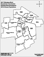 View map showing populations for all City of Winnipeg Wards.
Ward Boundary Maps
Click on a ward in the map below to view a PDF map.

Population Maps
The below maps display estimated neighborhood populations within each Ward based on 2016 census data.
All maps are in PDF file format.
This spreadsheet provides the neighbourhood populations based on 2016 census data.
Census Tract Maps
This spreadsheet provides the census tract data broken out by ward and geographic code.
Please see below tables for individual census tract maps. All maps are in PDF file format.
Charleswood - Tuxedo - Whyte Ridge
Daniel McIntyre
Elmwood - East Kildonan
Fort Rouge - East Fort Garry
Mynarski
North Kildonan
Old Kildonan
Point Douglas
River Heights - Fort Garry
South Winnipeg - St. Norbert
St. Boniface
St. Charles
St. James - Brooklands - Weston
St. Vital
Transcona
Last update:
September 15, 2017