Empress Street Improvements
Empress Street and Wellington Avenue need improvements. The infrastructure is aging and the ways people use the streets have changed over the years.
These streets are also important connections to Winnipeg Richardson International Airport, CF Polo Park, Portage Avenue and Route 90.
- Updates
- Background
- Timeline
- Documents
- FAQs
- Map
Updates
July 2025 – We met with area business and property owners in Summer 2024 and Winter 2025 to share design concepts. We made updates based on feedback and completed a study report with preliminary cost estimates. The project will now be prioritized against others for budget allocation.
June 2024 – We're reaching out to business and property owners throughout the project area to talk about how you access and use your property. If you believe you will be affected by construction but haven't yet heard from us, please reach out to Ryan Segal, Community Planner, Urban Systems, by email at rsegal@urbansystems.ca or by phone at 204-259-3691.
Background
Empress Street and Wellington Avenue need improvements. The infrastructure is aging and the ways people use the streets have changed over the years.
These streets are also important connections to Winnipeg Richardson International Airport, CF Polo Park, Portage Avenue and Route 90.
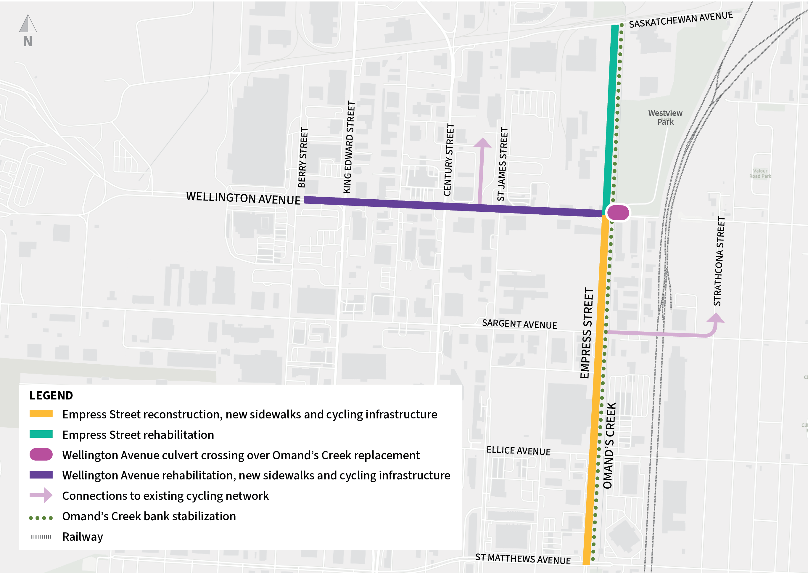
We're looking to improve Empress Street from St. Matthews Avenue to Saskatchewan Avenue and Wellington Avenue from Empress Street to Berry Street. This includes work on:
- Slope stability along Omand's Creek
- Traffic flow
- Gaps in the pedestrian and cycling network
- Transit changes from the new Transit Master Plan
The study will consider several improvements:
- Reconstructing Empress Street from St. Matthews Avenue to Wellington Avenue. This includes new sidewalks and cycling infrastructure.
- Rehabilitating Empress Street from Wellington Avenue to Saskatchewan Avenue.
- Replacing the Wellington Avenue culvert crossing structure over Omand's Creek.
- Stabilizing the west bank of Omand's Creek.
- Rehabilitating Wellington Avenue from Empress Street to Berry Street. This includes new sidewalks and cycling infrastructure.
- Connections to the existing pedestrian and cycling network.
This study is funded by the Non-Accelerated Regional Street Renewal Program and the Waterway Crossings and Grade Separations Annual Program.
Construction for these improvements is not funded or scheduled yet. It will depend on future budget decisions.
Documents
| Document Name | Date | Type |
|---|---|---|
| Empress Street Stakeholder Presentation | 2024-06-26 | Presentation |
| Wellington Avenue Stakeholder Presentation | 2024-07-22 | Presentation |
| Empress-Wellington Stakeholder Presentation | 2025-02-05 | Presentation |
Frequently Asked Questions
The study is investigating improvements to Empress Street north of St. Matthew's Avenue and Wellington Avenue west of Empress Street. This design will look to improve aging roads, stabilize Omand's Creek, improve traffic, add sidewalks and cycling infrastructure, and align with the new Transit Master Plan.
Right now, there is only funding for the design study. There is no budget or timeline for more detailed planning or construction.
We are reaching out to property owners who might be affected by this project to help us make sure the improvements fit with their property and operational needs. If you haven't heard from us and think you might be affected, please contact Ryan Segal, Community Planner, Urban Systems, by email at rsegal@urbansystems.ca or by phone at 204-259-3691.
We're looking at a number of potential safety improvements:
- Separated bike lanes and sidewalks on Empress Street from St. Matthews Avenue to Wellington Avenue
- Protected bike lanes and sidewalks on Wellington Avenue from Empress Street to Berry Street
- Connections to the existing pedestrian and cycling network at Sargent Avenue at Strathcona Street and St. James Street at Saskatchewan Avenue
- Improved lane channelization and new left turn lanes at traffic lights along Empress Street
- Better access to transit stops
We will also design pedestrian and bike paths to the latest accessibility standards. They will help people with visual impairments by clearly defining the walking path. There will also be shorter pedestrian crossings and better visibility to help drivers.
Right now we aren't doing anything. We're just looking at potential improvements.
That said, Empress Street currently has just one wide lane of traffic in each direction. We're recommending we make these lanes narrower to accommodate a new bike lanes and a sidewalk on the east side of Empress Street between the curb and Omand's Creek. This would look similar to Empress Street south of St. Matthews Avenue.
On Wellington Avenue, there are two lanes of traffic in each direction. East of St. James Street, the lane closest to the west curb is used for parking. The proposed plan is to change this parking lane into a protected bike lane from Empress Street to St. James Street and from Century Street to King Edward Street. The rest of Wellington Avenue would have a bike lane in the north boulevard.
The budget for this preliminary design study is $400,000. Construction is not yet funded.
On Wellington Avenue, the proposed plan moves some transit stops and adds more stops to make it easier to transfer between buses. Larger waiting areas would make it easier for people to see and use the stops.
Winnipeg Transit is making changes to service here independent of our project.
The side slopes of Omand's Creek are failing in some places and need to be stabilized. Just like the work done a few years ago south of St. Matthew's Avenue, we will use different methods to repair the slopes. We will also replant the areas with native plants.


