William R. Clement Parkway and Sterling Lyon Parkway Extensions
Functional and Preliminary Design Study
Update December 2017 – On December 13, 2017, Council approved the motion from the Standing Policy Committee on Infrastructure Renewal and Public Works that the William R. Clement Parkway component of this project is allowed to continue. Council decided that any planning for the east/west connection of the William R. Clement Parkway extension project must follow and be included in the Precinct Plan for the South Wilkes area.
The City will not approve or engage any major capital infrastructure planning in these areas until a new Precinct Plan is adopted by Council. Council, through the OurWinnipeg review, shall rank the prioritization of the South Wilkes Precinct as part of the OurWinnipeg and Complete Communities review.
- Updates
- Engage
- Timeline
- Background
- Documents
- FAQs
- Maps
- Related Links
Updates
Update December 2017
On December 13, 2017, Council approved the motion from the Standing Policy Committee on Infrastructure Renewal and Public Works that the William R. Clement Parkway component of this project is allowed to continue. Council decided that any planning for the east/west connection of the William R. Clement Parkway extension project must follow and be included in the Precinct Plan for the South Wilkes area.
The City will not approve or engage any major capital infrastructure planning in these areas until a new Precinct Plan is adopted by Council. Council, through the OurWinnipeg review, shall rank the prioritization of the South Wilkes Precinct as part of the OurWinnipeg and Complete Communities review.
Update July 2017
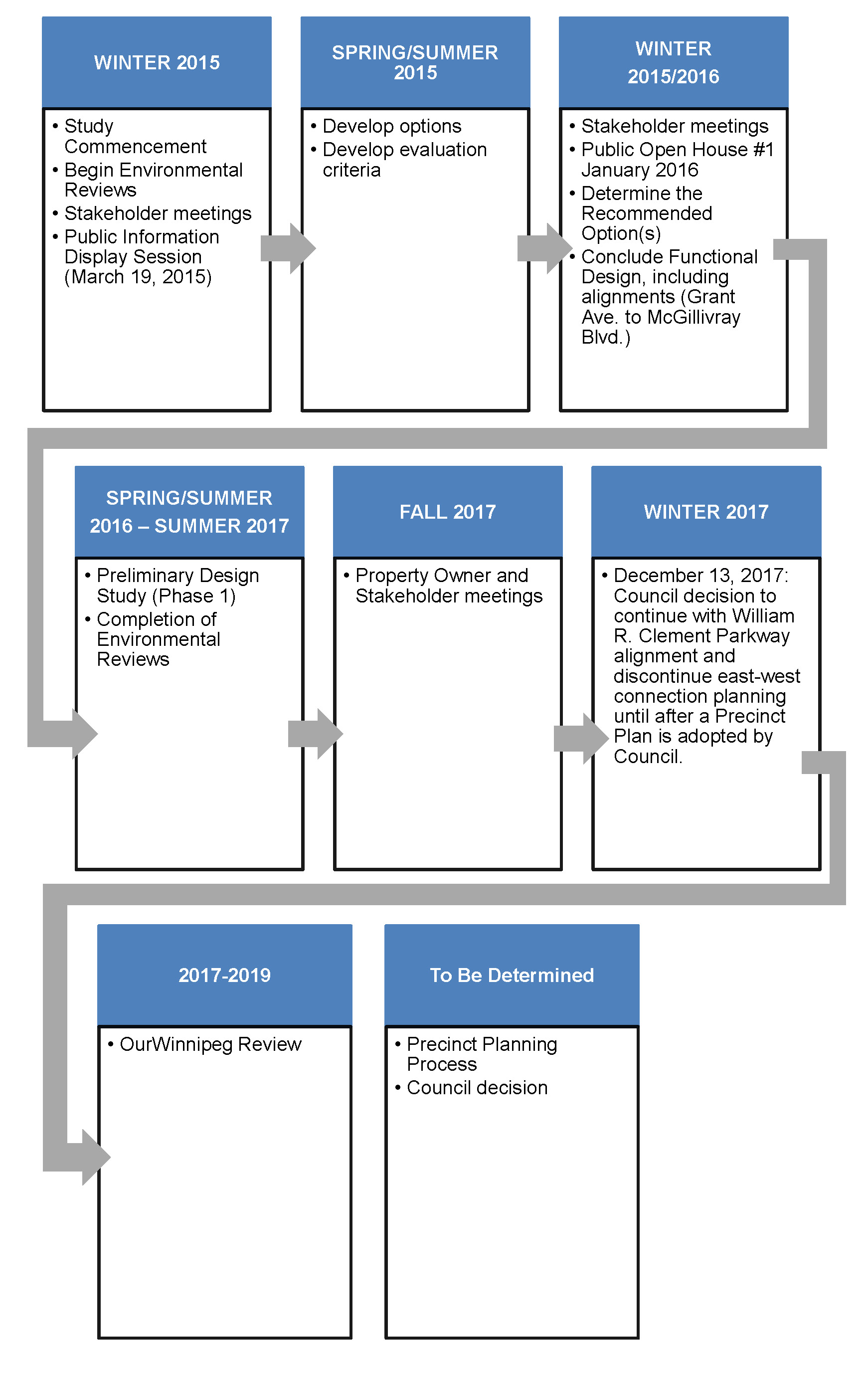
Due to project prioritization, the original timeline for this study was extended. The project team is currently updating stakeholders and residents with the revised project timeline. Landowner meetings and an open house will be held in the Fall of 2017 to discuss the draft preliminary design.
Engage
Thank you to those who have participated in the project so far through the information session, open house, and online surveys.
For more information, please contact:
Brad Neirinck, P. Eng., Manager of Engineering, Public Works Department
Email: BNeirinck@winnipeg.ca
Phone: 204-986-7950
If you would like to stay updated on City of Winnipeg public engagement events, follow the City on Facebook and Twitter or sign up for the City of Winnipeg public engagement newsletter.
Background
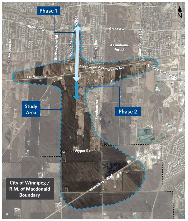
The City's Transportation Master Plan approved by City Council in November 2011 includes the William R. Clement Parkway (WRCP) Extension as a major transportation facility. The WRCP Extension is identified in the Transportation Master Plan as an important component of the City's strategic road network to accommodate the travel demand associated with future residential, commercial, and industrial growth in west Winnipeg.
The City's Transportation Master Plan identifies the extension of the WRCP between Grant Avenue and Wilkes Avenue as a medium-term project. However, on April 25, 2012, Council approved an amendment to the Transportation Master Plan resulting in this portion of the WRCP Extension becoming a short-term project. The future extension of the WRCP between a signalized intersection with the extension of SLP and McGillivray Boulevard is defined as a long-term project.
In December of 2013, the 2014 Capital Budget was approved by Council to include the Functional Design Study of WRCP Extension. In December of 2014, the Capital budget was amended to include funding from the Charleswood Transportation Levy to expand the scope of work to include studying twinning and realignment options for Wilkes Avenue.
Phase I - Shorter-term
- The recommended road network includes the extension of WRCP from Grant Avenue to a signalized intersection with the extension of SLP.
Phase II* - Longer-term
- Future extension of WRCP from SLP to McGillivray Boulevard.
*(as per Transportation Master Plan)
Study Scope:
- Conduct functional and preliminary design studies for the WRCP and SLP extensions
- Develop alignment options for an east-west connection south of the CN Mainline
- Develop grade separation options at the CN Mainline
- Develop alternatives for the Harte Trail crossing
- Identify potential dog park location(s)
- Obtain Environmental Act Licensing for Phase 1
- Conceptual Environmental Assessment Study for Phase 2
In March 2015, a public information display session introduced the public to the WRCP Extension study. Feedback from this event was considered in the development of alignment options for the study. In January 2016, an open house was held to share phase 1 design options and feedback from that event is being considered in the recommendation of the preliminary design.
In December 2017, Council reviewed and approved the motion from the Standing Policy Committee on Infrastructure Renewal and Public Works that the William R. Clement Parkway component of this project be allowed to continue but that planning for the east/west connection of the William R. Clement Parkway extension project must follow and be included in the Precinct Plan for the South Wilkes area. The City will not approve or engage any major capital infrastructure planning in these areas until a new Precinct Plan is adopted by Council.
Documents
| Document Name | Date | Type |
|---|---|---|
| Summary of Public Engagement Phase Two Functional and Preliminary Design Study | 2016-09-30 | Report |
| January 19, 2016 Open House Boards | 2016-01-19 | Storyboards |
| January 19, 2016 Open House Invitation | 2016-01-19 | Invitation |
| March 19, 2015 Public Information Session Display Boards | 2015-03-19 | Storyboards |
| March 19, 2015 Public Information Session Invitation | 2015-03-19 | Invitation |
| Council Decision: Wilkes Avenue Alignment to William R. Clement Parkway Extension
|
2017-12-13 | Meeting Minutes |
Frequently Asked Questions
The William R. Clement Parkway (WRCP) Extension is an important component of the City of Winnipeg's future transportation system, providing a north-south link in west Winnipeg. The City's Transportation Master Plan, which guides transportation planning in Winnipeg, includes the WRCP Extension as a major transportation facility, intended to accommodate future travel demand in the area.
The WRCP Extension will include an overpass of the CN mainline, a bridge for the Harte Trail, an environmental assessment, and integration of recreational opportunities such as parks and pathways. The study will not only look at improving the north-south movement of people, goods and services but will also look at improvement to Wilkes Avenue.
The City needs to proactively plan for future growth. The William R. Clement Parkway extension will support economic development, create recreational opportunities and will take us one step closer to the completion of the Strategic Inner Ring Road to reduce traffic on neighborhood streets.
This transportation corridor is intended to support local and regional economic growth for the City; the grade separation of the WRCP Extension at the CN Rail Line at Wilkes Ave., along with many other improvements, will provide more efficient movement of goods and services in the City.
This study is partially funded by the Charleswood Transportation Levy which was developed to support the improvement and development of transportation facilities for that area.
This project does not have a construction budget yet. Council has only approved the funding to conduct an engineering study.
There are a small number of privately owned properties that will need to be acquired should the William R. Clement Parkway (WRCP) Extension and Re-alignment of Wilkes Avenue construction project receive Council approval in the future.
The Dog Park area was always intended to be a temporary use of that property, as the City purchased that property many years ago with the intention of using it for a transportation corridor. The City understands the importance of the Charleswood Dog Park to area residents, and has identified a number of alternate locations within the area.
The project team includes a team of environmental and biology professionals who are performing an Environmental Assessment that includes the identification of environmentally sensitive areas. We will take measures to mitigate negative impacts where possible.
A key component of the study is to look at current and future traffic to adequately address traffic needs and to ensure public safety. We have considered a number of options for intersections along the extension including an underpass, overpass and signalized intersection.
On December 13, 2017, Council approved the motion from the Standing Policy Committee on Infrastructure Renewal and Public Works that the William R. Clement Parkway component of this project is allowed to continue. Council decided that any planning for the east/west connection of the William R. Clement Parkway extension project must follow and be included in the Precinct Plan for the South Wilkes area.
The City will not approve or engage any major capital infrastructure planning in these areas until a new Precinct Plan is adopted by Council. Council, through the OurWinnipeg review, shall rank the prioritization of the South Wilkes Precinct as part of the OurWinnipeg and Complete Communities review.
The William R. Clement Parkway component of the project will continue moving forward. Council decided the South Wilkes area requires a Precinct Plan before moving forward with determining an east/west connection. Council, through the OurWinnipeg review, shall rank the prioritization of the South Wilkes Precinct as part of the OurWinnipeg and Complete Communities review.