We are performing a system upgrade. Some online services and call centres may be intermittently unavailable from 9 p.m. March 26 to 5 a.m. March 27.


Southeast Corridor
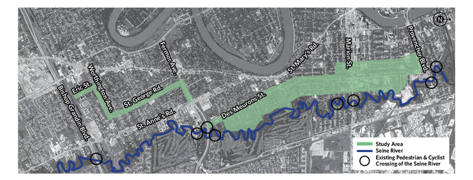
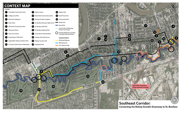
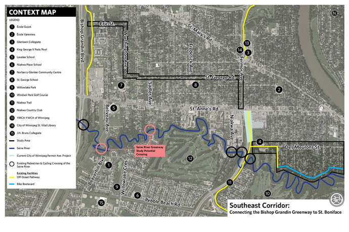
Connecting the Bishop Grandin Greenway to St. Boniface
This study is now complete.
The goal of the Southeast Corridor Study and Design, along the area around Des Meurons Street and St. George Road, is to provide pedestrian and cycling infrastructure that allows people of all ages and abilities to walk or bike from the Bishop Grandin Greenway to the St. Boniface neighbourhood. The infrastructure will start and end at safe locations and connect people from their neighbourhoods to existing and future bicycle infrastructure.
- Recommended Design
- Engage
- Timeline
- Background
- Documents
- FAQs
- Maps
Recommended Design
The recommended design for the Southeast Corridor is a neighbourhood greenway that will connect the St. Boniface neighbourhood to the Bishop Grandin Greenway. Neighbourhood greenways are routes on streets with low vehicle speeds and volumes, which include a range of treatments to slow down traffic and improve safety for walking, biking, and driving. Treatments range from signage, bike signals, and pavement markings to varying degrees of traffic calming (speed humps, traffic diverters, traffic circles, etc.). No property acquisition or land easements are needed for the recommended designs.
Further information on feedback provided by citizens throughout this study is available in the public engagement report.
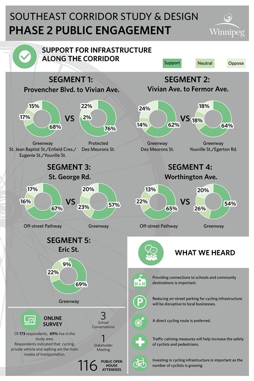
The Southeast Corridor will be recommended along St. Jean Baptiste Street, Enfield Cresent, Eugenie Street, Youville Street, Egerton Road, Des Meurons Street, Fermor Avenue, St. George Road, Worthington Avenue and Eric Street. A neighbourhood greenway has been recommended for the entire corridor, which was broken into five segments:
Segment 1: Provencher Boulevard to Vivian Avenue - Neighbourhood Greenway
- This design is recommended as it provides connections to schools (i.e., École Henri Bergeron School, École Provencher, and Collège Louis Riel) as well as community destinations (i.e. Notre Dame Recreation Centre), and has lower impact to traffic operations, parking and public transit.
- A neighbourhood greenway was selected due to the lower comparative cost and shorter implementation period.
- Public comments suggested support for this option as it provides connections to local schools and community centres, increases the safety of cyclists by slowing down and reducing traffic volumes, creates a local route for community residents and recreational users, and can be implemented in the short-term.
Design Features
- The installation of signage, pavement markings, a traffic diverter, and traffic calming features such as speed humps, raised crosswalks, and raised intersections will create a more bicycle and pedestrian-friendly street.
- Traffic signals are recommended at the intersections of Enfield Crescent at Marion Street, Enfield Crescent at Goulet Street, and Eugenie Street at Des Meurons Street to accommodate pedestrian and cyclists crossing these high traffic volume streets.
Segment 2: Vivian Avenue to Fermor Avenue - Neighbourhood Greenway
- This option is recommended as the very low traffic volumes on these local streets make them safe for pedestrians and cyclists and there is lower impact to traffic operations and parking.
- Public comments suggested support for this option as the low traffic volumes are perceived to be safer for cyclists, it creates a local route for community residents and recreational users, and the option can be implemented in the short-term for a lower comparative cost.
Design Features
- Incorporates the existing bicycle route along Youville Street and Egerton Road with the addition of signage and pavement markings to further identify these streets as a neighbourhood greenway.
- Raised crosswalks on Des Meurons Street are also recommended to improve the pedestrian crossings in the area of Glenwood School and Glenwood Community Club.
Segment 3: St. George Road (Fermor Avenue to Worthington Avenue) – Neighbourhood Greenway
- The two options (view full information on the options provided) for this segment were both considered to have a positive impact on the community and provide a similar level of pedestrian and cyclist comfort.
- A neighbourhood greenway was selected primarily due to the lower comparative cost and shorter implementation period.
- Public comments suggested support for this option as the low traffic volumes are perceived to be safer for cyclists, it creates a local route for community residents and recreational users, and the option can be implemented in the short-term for a lower comparative cost.
Design Features
- This option includes the installation of signage, pavement markings, and traffic calming features such as speed humps, traffic circles, raised crosswalks, and raised intersections to create a more bicycle and pedestrian-friendly street.
- Raised crosswalks are recommended in the area of St. George School to provide improved pedestrian crossings for children to access the school.
- Traffic circles are recommended at Havelock Avenue, Poplarwood Avenue, and Sadler Avenue to slow through traffic on St. George Road while also allowing cyclists to flow through along the route.
Segment 4: Worthington Avenue (St. George Road to Eric Street) – Neighbourhood Greenway
- This option is recommended as Worthington Avenue has low traffic volumes making it safe for pedestrians and cyclists, and a neighbourhood greenway helps maintain consistent cycling infrastructure as a neighbourhood greenway is recommended for adjacent segments 3 and 5.
- A neighbourhood greenway was also selected due to the lower comparative cost and shorter implementation period.
- Public comments suggested support for this option as it creates a local route for community residents and recreational users, and can be implemented in the short-term for a lower comparative cost.
Design Features
- This option includes the installation of signage and pavement markings to identify and highlight Worthington Avenue as a neighbourhood greenway.
Segment 5: Eric Street (Worthington Avenue to Bishop Grandin Greenway) – Neighbourhood Greenway
- This option is recommended as Eric Street has low traffic volumes, making it safer for pedestrians and cyclists and has low impact to traffic operations and parking.
- A neighbourhood greenway was also selected due to the lower comparative cost and shorter implementation period.
- Public comments suggested support for this option as it provides a direct connection to the Bishop Grandin Greenway, creates a local route for community residents and recreational users, and it can be implemented in the short-term for a lower comparative cost.
Design Features
- This option includes the installation of signage, pavement marking, and traffic calming features such as a raised crosswalk to create a more bicycle and pedestrian-friendly street.
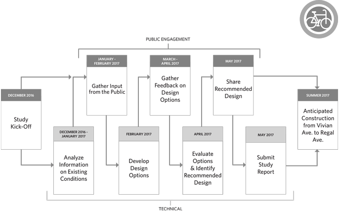
Next Steps
Currently no funding has been identified for the project.
Engage
The goal of the public engagement is to collect feedback throughout the design process to help determine the following:
- Type of infrastructure
- Location of infrastructure;
- Network connections;
- Intersection upgrades (type and location);
- Evaluation criteria (and weighting).
The information gathered throughout the engagement period is now available through the public engagement summary and full public engagement report.
Review the recommended design tab to see images and descriptions of what has been proposed.
Previous and ongoing activities
Phase 2
Thank you to all who attended the open houses on April 4 and 5. Approximately 100 people attended the open houses and approximately 26 surveys were collected. An additional 147 surveys were also collected online.
Phase 1
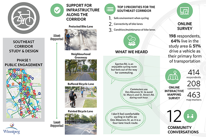
An online survey and mapping tool were available from January 31 to February 20. The project team has also been meeting with community members and schools to gather information and knowledge about the area.
Background
In November 2011, City of Winnipeg Council approved the Transportation Master Plan (TMP). A key goal of the TMP is to expand the range of travel options that are available to residents, workers, and visitors, as well as to ensure that people are not dependent on one single mode of transportation. The TMP also calls for the development of the Pedestrian and Cycling Strategies.
In 2015, City Council approved the Winnipeg Pedestrian and Cycling Strategies, which provide a long-range policy framework for active modes of transportation for the next 20 years.
On May 18, 2016 City of Winnipeg Council approved the 2016 Pedestrian and Cycling Action Plan (Action Plan) that authorizes the Public Service to proceed with this project.
This project will develop local networks for neighbourhoods to connect to existing and planned cycling infrastructure and to downtown. The study will be the basis for the inclusion of cycling infrastructure in immediate and future street renewal programs.
Documents
| Document Name | Date | Type |
|---|---|---|
| Phase 1 - School Workshop Invitation | 2017-02-08 | Community Letter |
| Phase 1 - Community Mailout | 2017-02-01 | Community Letter |
| Phase 1 - News Release | 2017-02-01 | News Release |
| Phase 2 - Community Mailout | 2017-03-24 | Community Letter |
| Phase 2 - News Release | 2017-03-24 | News Release |
| Phase 2 – Open house materials | 2017-03-23 | Open house materials |
| Public Engagement Report | 2017-07-11 | Report |
| Recommended design | 2017-07-06 | Report |
| Public Engagement Summary | 2017-07-11 | Report |
Frequently Asked Questions
Are you putting in bike lanes?
We are studying all potential options that will allow people of all ages and abilities to walk or bike from Provencher Boulevard to the Bishop Grandin Greenway.
What is being done around Fermor Avenue?
Another study is currently being conducted to develop a preliminary design for rehabilitation and improvements to the walking and biking network in the area. For more details please visit the Fermor Avenue Bridge over Seine River Rehabilitation and Roadworks project website.
When will this be constructed?
Currently no funding has been identified for this project.
How will this impact parking?
Land-use and parking varies along the study route. Parking implications will be studied and presented to the public as the project progresses.
Why aren’t you studying St. Anne’s Road as a corridor?
On May 3, 2016 the Standing Policy Committee on Infrastructure Renewal and Public Works recommended to include the parameters set out in this study. A key direction of the Pedestrian and Cycling Strategies is to develop local bicycle networks for each neighbourhood that connects to the spine network and downtown. This would serve as south east cycling and walking corridor for Winnipeg.
What are the City of Winnipeg Pedestrian and Cycling Strategies?
On July 15, 2015, City Council adopted the Winnipeg Pedestrian and Cycling Strategies (the Strategies). This document stems from the 2011 Transportation Master Plan. The Strategies provide a long-range policy framework for active modes of transportation in Winnipeg for the next 20 years. Following public engagement with more than 3,000 Winnipeggers in 2013, the Strategies will assist in the prioritization of walking and cycling infrastructure projects city-wide based on further in-depth engagement with neighbourhood and local stakeholders on a per project basis.
How can I stay involved in the project?
Join our email list to be notified about upcoming engagement activities, look at the "Engage" tab on this website, and follow the City of Winnipeg on Facebook and Twitter .
Last update:
January 8, 2020