William R. Clement Parkway and Sterling Lyon Parkway Extensions
Functional & Preliminary Design Study
The public was invited to provide their feedback at an open house for the William R. Clement Parkway (WRCP) Extension Functional & Preliminary Design Study on Tuesday, January 19, 2016 from 4:00 pm to 7:30 pm at Charleswood United Church, 4820 Roblin Boulevard. The public was also invited to provide their feedback through an online survey.
The open house Information Boards provide the study details. Feedback received at this open house and through the online survey has been summarized into a report.
We thank all who participated; your feedback will assist in the creation of the recommended design.
The WRCP and Sterling Lyon Parkway (SLP) Extensions are important components of the City of Winnipeg’s future transportation system, providing north-south and east-west links in west Winnipeg. The City’s Transportation Master Plan, which guides transportation planning in Winnipeg, includes the WRCP Extension as a major transportation facility, to accommodate future travel demand in the area. In March 2015, a public information display session introduced the public to the WRCP Extension study. Feedback from this event was considered in the development of alignment options for the study.
The City of Winnipeg has commenced a study to guide the implementation of the WRCP and SLP extensions, which consists of two phases:
Phase I - Short-term
- The recommended road network includes the extension of WRCP from Grant Avenue to a signalized intersection with the extension of SLP.
Phase II* - Long-term
- Future extension of WRCP from SLP to McGillivray Blvd.
*(as per Transportation Master Plan)
Study Scope:
- Conduct functional and preliminary design studies for the WRCP and SLP extensions.
- Develop alignment options for an east-west connection south of the CN Mainline.
- Develop grade separation options at the CN Mainline.
- Develop alternatives for the Harte Trail crossing.
- Identify potential dog park location(s).
- Obtain Environmental Act Licensing for Phase 1.
- Conceptual Environmental Assessment Study for Phase 2.
Study Area:
Download the study area map.
Study Background:
The City's Transportation Master Plan approved by City Council in November 2011 includes the WRCP Extension as a major transportation facility. The WRCP Extension is identified in the Transportation Master Plan as an important component of the City's strategic road network to accommodate the travel demand associated with future residential, commercial, and industrial growth in west Winnipeg.
The City's Transportation Master Plan identifies the extension of the WRCP between Grant Avenue and Wilkes Avenue as a medium-term project. However, on April 25, 2012, Council approved an amendment to the Transportation Master Plan resulting in this portion of the WRCP Extension becoming a short-term project. The future extension of the WRCP between a signalized intersection with the extension of SLP and McGillivray Boulevard is defined as a long-term project.
Public Participation:
Public and stakeholder participation is an important part of this process. The project team, working in conjunction with a City of Winnipeg Steering Committee, will seek input from stakeholders and the public on key concerns and considerations within the study area through multiple public events and meetings.
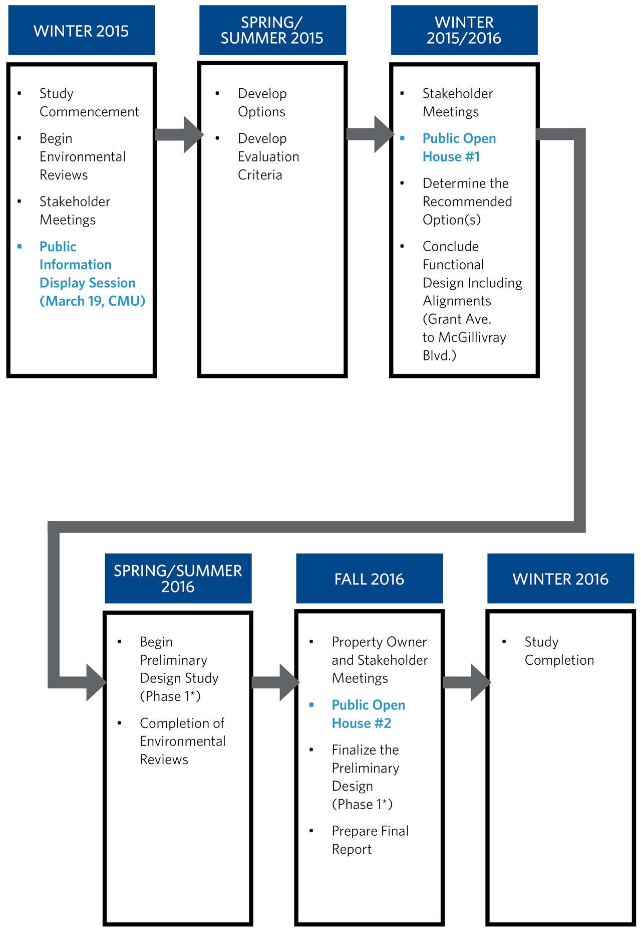
Study Timeline:

For More Information Contact: 311
Dave Jopling, Manager Planning and Design, MMM Group Limited
Email: joplingd@mmm.ca
Phone: 204-943-3178
Links:
 |
||
| Our Winnipeg | Active Transportation Network | Transportation Master Plan |

